Professional Drone Services Designed for Clarity, Accuracy,
Roof Inspection
Photography and Videography
Roof Inspection
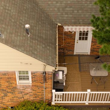
Drone roof inspections utilize advanced aerial mapping techniques to provide a safer, faster, and more cost-effective way to assess roof conditions without the need for ladders or scaffolding, ensuring minimal disruption to your property. With high-resolution aerial photography, we capture detailed views of damage, wear, and potential pro
Drone roof inspections utilize advanced aerial mapping techniques to provide a safer, faster, and more cost-effective way to assess roof conditions without the need for ladders or scaffolding, ensuring minimal disruption to your property. With high-resolution aerial photography, we capture detailed views of damage, wear, and potential problem areas that are often difficult—or dangerous—to see from the ground. This makes our drone services ideal for homeowners, roofing contractors, and insurance claims. Inspections are completed quickly with minimal risk, delivering clear documentation you can trust for maintenance planning or decision-making. Contact us today to schedule your drone roof inspection and receive a precise, professional view from above—on demand.
Site Mapping
Photography and Videography
Roof Inspection
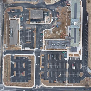
Drone services for aerial mapping provide fast, accurate, and up-to-date aerial data that empowers you to plan, measure, and manage projects with confidence. Utilizing advanced drone technology, we capture detailed aerial photography and mapping data that aids in property assessments, construction planning, land development, and progress
Drone services for aerial mapping provide fast, accurate, and up-to-date aerial data that empowers you to plan, measure, and manage projects with confidence. Utilizing advanced drone technology, we capture detailed aerial photography and mapping data that aids in property assessments, construction planning, land development, and progress tracking—often in a fraction of the time and cost compared to traditional methods. The outcome is clear, actionable insight with minimal site disruption. Contact us today to schedule your drone site mapping service and obtain precise aerial data when you need it most, including for roof inspections.

Photography and Videography
Photography and Videography
Photography and Videography
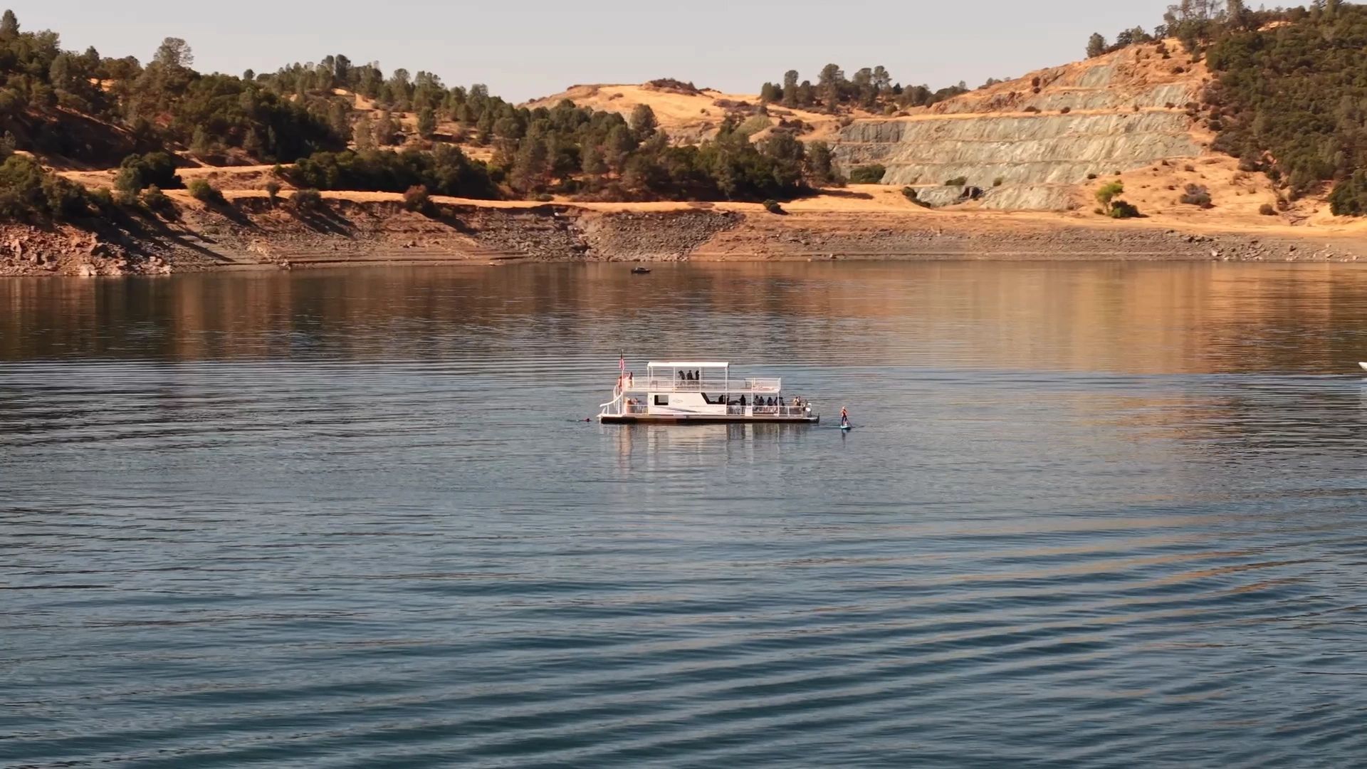
Aerial photography and videography through our drone services provide stunning perspectives from above that capture attention and tell a compelling visual story. Whether you need aerial mapping for projects, showcasing real estate, conducting a roof inspection, promoting a business, or creating cinematic content, high-resolution photos an
Aerial photography and videography through our drone services provide stunning perspectives from above that capture attention and tell a compelling visual story. Whether you need aerial mapping for projects, showcasing real estate, conducting a roof inspection, promoting a business, or creating cinematic content, high-resolution photos and smooth, professional video elevate your visuals far beyond ground-level shots. Aerial media adds scale, context, and impact—helping you stand out and connect with your audience. Contact us today to schedule your drone services for photography or videography and bring your vision to life from the sky.

Our Mission
Certified Expertise You Can Trust
Our vision is to deliver precise, reliable, and innovative aerial solutions, including aerial mapping and aerial photography, that help people make smarter decisions, work safer, and see more clearly from above. We strive to set the standard for professional drone services by combining advanced technology, skilled operation, and responsiv
Our vision is to deliver precise, reliable, and innovative aerial solutions, including aerial mapping and aerial photography, that help people make smarter decisions, work safer, and see more clearly from above. We strive to set the standard for professional drone services by combining advanced technology, skilled operation, and responsive service—while continually expanding our capabilities to meet real-world needs. As we grow, our goal is to use aerial technology not only to support businesses and property owners through services like roof inspection, but also to assist communities with future offerings such as search, recovery, and rescue when it matters most.
Certified Expertise You Can Trust
Certified Expertise You Can Trust
As a certified NIST sUAS Instructor and Proctor for Levels 1, 2, and 3, I provide professional, standards-based training and official proficiency testing using the National Institute of Standards and Technology’s aerial drone test methods. My expertise extends to various applications, including aerial mapping and aerial photography, ensur
As a certified NIST sUAS Instructor and Proctor for Levels 1, 2, and 3, I provide professional, standards-based training and official proficiency testing using the National Institute of Standards and Technology’s aerial drone test methods. My expertise extends to various applications, including aerial mapping and aerial photography, ensuring pilots are well-equipped for diverse drone services. From basic flight proficiency and precise maneuvering (Levels 1 & 2) to complex open-environment navigation and scenario-based tasks (Level 3), I equip pilots with measurable skills that meet the highest industry benchmarks for safety, control, and operational readiness, including specialized tasks like roof inspection.

FAA Part 107 Certified for Commercial Operations
FAA Part 107 Certified for Commercial Operations
As a FAA Part 107 licensed Remote Pilot, I am fully authorized by the Federal Aviation Administration to operate small unmanned aircraft systems (sUAS) commercially throughout the United States. This certification confirms my thorough knowledge of FAA regulations, airspace rules, weather analysis, drone maintenance, and safe operating pro
As a FAA Part 107 licensed Remote Pilot, I am fully authorized by the Federal Aviation Administration to operate small unmanned aircraft systems (sUAS) commercially throughout the United States. This certification confirms my thorough knowledge of FAA regulations, airspace rules, weather analysis, drone maintenance, and safe operating procedures. I can legally and professionally provide a range of drone services, including aerial photography, aerial mapping, roof inspection, real estate imaging, infrastructure inspections, and surveying, all while maintaining the highest standards of safety and regulatory compliance.


Contact Us
We'd love to hear from you!
Do you have a question about our drone services? Whether you're interested in aerial photography, aerial mapping, or a roof inspection, send us the details of your project, and we'll be happy to provide you with a free quote and additional information.
Message us on WhatsApp
Delaware Valley Drones
